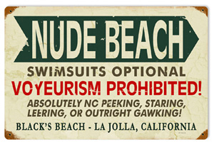
Black’s Beach in San Diego is located just north of La Jolla Shores and beneath the Torrey Pines bluffs. It is named after the Blacks family, who once owned a horse farm on the cliffs overlooking the beach. San Diego Black’s Beach is now broken into two portions, a northern and southern region. The northern territory is owned by the state park while the southern portion is owned by the city. Don’t be surprised if you see beach goers flashing a little extra skin than usual because in the northern state park run area of the Black’s Beach nudity is permitted. The bikini and swim trunks optional stretch of San Diego Black’s Beach is a little over a mile and a popular spot for Southern California nudists and naturists.
San Diego Black’s Beach is also famous among surfers as it is considered one of the strongest surf breaks in Southern California. The powerful waves are due to the Scripps Canyon, an underwater submarine canyon, which funnels the waves toward the shore. The surf in Black’s Beach San Diego is recommended for experienced surfers only, and although there are lifeguards on duty, swimmers are advised to avoid the rip currents at San Diego Black’s Beach. Black’s Beach visitors should also check out the sky to catch sight of flights, as the cliffs are a common area for daring hang gliders and paragliders to take off into the air.
There are several ways to reach the secluded San Diego beach, but beach goers are to be warned about the unmaintained trails, high cliffs and the risk for landslides. Also, depending on the trail taken to Black’s Beach San Diego, some visitors may encounter high tide or strong surf. The four access routes include the Torrey Pines Glider Port Trail, which is the most used, but also considered an unstable route, the Torrey Pines State Park entrance, and the Torrey Pines State Beach and La Jolla Shores access, which are both blocked at high tide. Although the hike down to San Diego Black’s Beach can be a treacherous one, the private sand and sea are well worth the extra effort.
- Warning: Hikers should use caution when accessing the 300-foot cliff trails down to the shore.
- Nudity: Swimsuits are optional in the northern portion of Black’s Beach in San Diego.
- Directions: From 5 FWY take Carmel Valley Road west toward Pacific Coast Highway.
– See more at: http://www.sandiego.com/beaches/blacks-beach#sthash.oESBTbCz.dpuf
Directions
The physical address for the Torrey Pines Glider Port (which is the main parking area for Black’s) is:
2800 Torrey Pines Scenic Drive, 92037
The main parking lot for Black’s is actually called Torrey Pines City Park. It is more commonly known as the Torrey Pines Glider Port parking lot. The beach is just North of La Jolla and just minutes from the Interstate 5 freeway.
FROM THE FREEWAY
The most direct way to the beach is to exit Interstate 5 at Genesee Ave. and head West. At the top of the hill turn LEFT onto North Torrey Pines Rd. (which is the first LEFT after getting away from the freeway). Turn RIGHT onto Torrey Pines Scenic Dr. (Second light). Follow this into the parking lot at the end of the street. You can park on the street or just after entering the lot. There is also more parking straight ahead at the top of another trail leading to the beach. Most of us park to the left after just entering the lot.
MAIN TRAIL
If you parked after just entering the lot, head toward the water and follow the well traveled trail at the South-West corner of the lot. The start of the main trail is a paved section through the opening between a short chain link fence and wood posts connected with chain. There is also a brown sign that says “No Beach Access.” Don’t let this deter you! This is the safest and most maintained trail to the beach. It’s about as wide as a sidewalk and is gently sloped with many stairs.
SECONDARY TRAIL
There is another trail at the North end of the parking lot. This trail is very steep and sometimes slippery. There are steps cut into the dirt, but they do get worn away often. If you’re uneasy with heights, I’d avoid this trail.
LIFEGUARD ROAD
There is a paved road that you can walk down to access the beach. Parking is very limited and has a 2 hour time limit on weekdays. No limit on weekends. There is only space for about 30 cars and is very popular with surfers. This is where Blackgold Rd. meets La Jolla Farms Rd. You can’t drive down but it is an easier hill. The draw back is that you have to walk about a mile North on the sand to get to the clothing optional section.
FROM LA JOLLA SHORES
Just walk North on the sand from La Jolla Shores a little over two miles to the clothing optional section.
FROM TORREY PINES STATE PARK
Walk South past flat rock. The clothing optional section starts after getting through the area where the rocks go all the way into the water. This section is about 100 yards long and the beach opens up after getting through it.


